


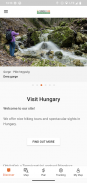

Természetjáró, a túratervező
Description de Természetjáró, a túratervező
Le guide touristique en ligne de la Hongrie, spécialement développé pour les randonneurs, les cyclistes, les trailrunners, les grimpeurs et les amateurs de sports nautiques, comprenant un planificateur de circuits intégré, ainsi que des centaines de circuits recommandés et des milliers de sites touristiques, le tout avec des descriptions détaillées et de nombreuses photographies. , confortablement visible sur une carte interactive. Disponible gratuitement, avec une option d'abonnement pour des fonctionnalités étendues.
Fonctionnalités
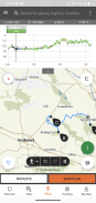
• Diverses cartes interactives, zoomables et vectorisées de randonnées mondiales avec tous les sentiers balisés, indiquant votre position actuelle
• Un moyen pratique de planifier votre propre circuit sur la carte et d'obtenir immédiatement la longueur, la durée et le profil d'altitude.
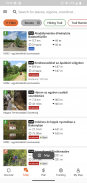
• Plus d'un millier de circuits recommandés pour les randonneurs, les cyclistes, les coureurs de trail et les canoéistes, avec des données pratiques, une description détaillée des meilleurs sites touristiques à proximité, un contexte naturel et culturel, des photographies de bonne qualité et des informations sur comment s'y rendre.
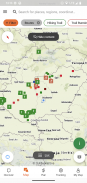
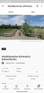
• Des milliers de sites recommandés en Hongrie, notamment des tours d'observation, des points de panorama naturels, des trains forestiers, des forteresses et des musées, avec une description détaillée, des photographies de bonne qualité et des informations sur la façon de s'y rendre.
• Des centaines de hébergements, dont des refuges, des hôtels touristiques et des appartements, à proximité des sentiers balisés
• Collections utiles avec vue cartographique : plages autour du lac Balaton, patinoires, jardins botaniques, les meilleurs itinéraires de trail, sites d'escalade, visites pour personnes handicapées, etc.
• Avis, avertissements et fermetures
• Télécharger des sections de carte, des visites et des sites touristiques pour une utilisation hors ligne
• navigation à la volée le long de l'itinéraire avec un profil d'altitude en direct et des instructions vocales
• Enregistrez votre itinéraire
• BuddyBeacon : partagez votre position avec vos amis en direct
• Le Tour bleu hongrois complet, avec sections et itinéraire officiels, POI et hébergement
• Synchronisez tout votre contenu entre l'ordinateur et les appareils mobiles exécutant l'application.
• Consultez les prévisions météorologiques locales
• Vol en 3D : une vue virtuelle à vol d'oiseau de la visite
• Des outils utiles intégrés, tels que le Peak Finder(Skyline) et la boussole avec votre position actuelle.
• Services communautaires : évaluez et partagez des contenus avec vos amis
Montres intelligentes avec WEAR OS de Google
D'un simple coup d'œil sur votre Smartwatch, vous obtenez des informations sur votre position GPS sur la carte. Vous pouvez enregistrer des traces, obtenir des données de suivi et naviguer le long des itinéraires. Utilisez la vignette de l'application pour accéder facilement aux itinéraires à proximité.
Exclusivement réservé aux membres Pro
Allez n'importe où : Outdooractive Pro fonctionne hors ligne sans signaux mobiles ni données. Des listes illimitées peuvent également être créées et l'application est sans publicité. De plus, vous pouvez visualiser des images satellite, la carte unique Outdooractive avec plus de 30 réseaux de sentiers d'activités et des cartes topographiques officielles des fournisseurs suivants :
Great Britain Ordnance Survey, Landranger, Explorateur
Informations foncières en Nouvelle-Zélande
USGS de l'Utah
Allemagne BKG
Autriche BEV
Suisse swisstopo
IGN France
Espagne CNIG
Italie
Pays-Bas PDOK
Norvège Kartverket
Danemark Kortforsyningen
Suède Lantmäteriet
Enquête nationale sur les terres finlandaises
Japon GSI
Carte globale
Exclusivement pour les membres Pro+
Pro+ contient également des cartes officielles des associations alpines ainsi que des cartes premium de KOMPASS.
Si vous avez des questions ou des suggestions, veuillez visiter
https://www.termeszetjaro.hu/hu/p/gyakran-ismetelt-kerdesek/41050512 /
Notre version de bureau :
https://www.termeszetjaro.hu/
Suivez-nous sur Facebook :
https://www.facebook.com/Termeszetjaro.hu/
Contactez-nous :
termeszetjaro@termeszetjaro.hu
En savoir plus sur la carte TEKA :
http://www.termeszetjarokartya.hu/
Természetjáró, a túratervező - Information APK
Version APK: 3.19.4Package: com.outdooractive.mtszAncienne Version de Természetjáró, a túratervező
Autres versions


Applications de même catégorie

Vous pourriez également aimer...


